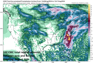
Tremendous rainfall amounts are likely during the remainder of the week up and down the eastern seaboard. Map courtesy Canadian Met Centre
Tropical Storm Debby is about to move back out over the open waters of the Southwest Atlantic Ocean…just off the coast of South Carolina. This system will re-intensify some during the next 24 hours or so – perhaps back to category 1 hurricane status – and then it’ll likely make a second landfall early Thursday in South Carolina. Whether or not Debby returns to hurricane status, there will be extreme rainfall amounts in portions of the Southeast US during the next couple of days centered on the state of South Carolina.
Farther north, much of the Mid-Atlantic region will experience very heavy rainfall and severe thunderstorms from later Tuesday into early Wednesday due to a combination of tropical moisture feeding northward from Tropical Storm Debby and an incoming strong cold frontal system. The remnants of Tropical Storm Debby will finally get kicked to north late in the week with heavy rainfall and potentially even tornadoes a threat in the entire Mid-Atlantic region on Friday/Friday night.
All of this rain can have a been impact on many big league games during the remainder of the week from the Southeast US (e.g., Atlanta Braves) to the Mid-Atlantic region (e.g., New York Yankees). In addition, the cold frontal system that pushes the Mid-Atlantic by mid-week will usher in much cooler air for the remainder of the week. The combination of the cooler temperatures to come and copious amounts of clouds in this wet weather pattern will tend to inhibit the levels to which the Home Run Forecast Index (HRFI) can reach. Indeed, some “3’s” and “4’s” will be showing up after a several week absence; especially, across some of the cooler Upper Midwest baseball cities (e.g., Cleveland, Chicago).
Meteorologist Paul Dorian

